WEATHER FACSIMILE WORLDWIDE
From satellites to ships at sea
by CHARLES JACKSON, Antic Technical Editor
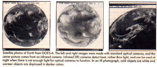
Satellite photos of Earth from GOES-6. The left and right images were made with standard optical cameras, and the center picture comes from an infrared camera. Infrared (IR) cameras detect heat, rather than light, and can be used at night when there is not enough light for optical cameras to function. In an IR photograph, cold objeas are white and warmer objects are displayed in darker colors.
WEFAX (pronounced WEE-fax) is short for Weather Facsimile and refers to a method of transmitting photographs and weather satellite maps via radio and telephone lines. WEFAX is a joint project of the National Oceanic and Atmospheric Administration (NOAA) and the National Environmental Satellite, Data and Information Service (NESDIS).
One important use of WEFAX is to receive facsimile weather maps from satellites, add additional information such as drawing a map of the globe over them, and relay them to ships at sea. Shipping and fishing industries throughout the world rely on satellite weather data every day.
Meteorologists use weather satellite data to measure ozone, water vapor and pollution levels; to plot storms, jet streams and fronts; and to monitor fog, snow and ice cover. Weather satellite photos have also been used to monitor river levels and to detect forest fires. For example, the National Weather Service in Redwood City, California, used photographs from the GOES-6 satellite to help emergency workers locate many of the larger wildfires; at Big Sur, California, on June 11, 1985.
WEFAX data is collected and transmitted 24 hours a day by more than 1,000 manned and unmanned weather stations. The first weather satellite, TIROS I, (Television and Infrared Observation Satellite) was launched April 1, 1960, and placed into an orbit 600 miles above the earth. Meteorologists used the TIROS photographs to monitor cloud cover and forecast the weather.
By 1966, NASA had launched ten TIROS satellites, which began photographing the entire earth daily, a project which continues to this day.
Most modern weather satellites are equipped with sensitive cameras which cover several wavelengths in the visible light and infrared (IR) spectrum. These cameras can detect objects as small as 1,000 yards across.
THE WEFAX CYCLE
Approximately one-third of the WEFAX pictures intended for the United States come from one of the polar orbiting NOAA satellites. The remainder come from a Geostationary Operational Environmental Satellite (GOES).
A satellite picture usually makes several stops on its way from earth orbit to a ship at sea. Basically, the satellite broadcasts an image to a "master" ground station. This station cleans up the image and relays it to satellite field service stations throughout the country. These "secondary" stations relay the images and weather maps to ships at sea, or to your Atari.
Let's follow a satellite image from earth orbit to your Atari.
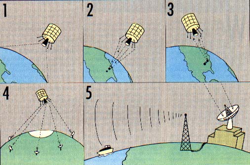
1. The satelites form a high-resolution full-disk image of the earth. These images are usually optical photographs (Figure 1), or infrared photographs (Figure 2).
2. The satellite transmits the image to a ground station in Wallops Island, Virginia. The image is transmitted on an S-band (microwave) frequency, usually 1691.0 mHz. Satellite pictures are normally transmitted every 30 minutes.
The Wallops Island facility is known as a Command and Data Acquisition station, or CDA. A CDA can receive data from a satellite and transmit instructions to control and position it.
The CDA transmits this data (via telephone lines) to the Central Data Distribution Facilities (CDDF) in the World Weather Building located in Suitland, Maryland.
3. At the CDDF, an image processing computer magnifies the full-disk picture, enhances it, draws a map over it, divides it into four quarter-disk pictures (Figure 3) and sends it back to the CDA at Wallops Island. The CDA transmits the processed ("massaged") satellite picture back to a GOES satellite on a similar S-band frequency of 2032 mHz.
4. The GOES satellite, now acting like a communications satellite, relays the picture to several Satellite Field Service Stations, such as WSFO in Redwood City which broadcasts over the NMC transmitter at nearby Point Reyes.
5. The Field Service Stations receive the satellite transmissions, record them on a high-quality tape and print the associated images on a facsimile machine. Meteorologists at the Field Service Station use these images to plot weather maps and make their forecasts. Finally, the Field Service Station transmits these images (satellite photos as well as weather maps) to ships at sea and other users (like us). These images are transmitted via the shortwave radio bands.
The National Meteorological Center in Washington, D.C. also transmits weather maps and charts in this fashion.
More than 1,000 WEFAX stations are located in 80 countries throughout the world. Foreign stations often use GOES information, or they may relay pictures from their own geostationary weather satellites. Japan, for example, operates the GMS satellite at 140 degrees longitude. This satellite covers the western Pacific. The Soviet GOMS satellite monitors the Indian Ocean (The USSR also uses a polar orbiting satellite, called METEOR). You could try receiving the European Space Agency's Meteosat broadcasts. Meteosat, located at 0 degrees longitude, covers the eastern Atlantic Ocean.
The Field Service statian transmitters in the United States include:NMC Point Reyes, California NAM Norfolk, Virginia KVM Honolulu, Hawaii NPM Pearl Harbor, Hawaii NOJ Kodiak, Alaska WWD La Jolla, California NFM Boston, Massachusetts
FINDING A WEFAX SIGNAL
Tune to one of the frequencies given below with a good shortwave receiver capable of receiving SSB (single sideband).
If you've never heard the chirping of a WEFAX signal, Listing 4, a WEFAX simulator, will help you identify them. Type in Listing 4, WESIM.BAS, check it with TYPO II and SAVE a copy to disk before you RUN it. When RUN, the program generates a simulated WEFAX signal. Keep this sound in mind when hunting for real WEFAX signals in the shortwave bands. WESIM.BAS also identifies the different parts of a WEFAX signal, such as the "start tone," the "phasing pulses" and the parts which contain picture information.
If you live in the Western United States, try to receive U.S. Coast Guard Station NMC, in Point Relies, Ca. NMC broadcasts on these frequencies (kHz.): 4346.0, 8682.0, 12730.0, and 17151.2 at the following times (GMT): 0100, 0300, 0500, 1500, 1715, 2000 and 2330.
NPM, in Pearl Harbor, Hawaii, (which Antic nicknamed "old reliable") transmits WEFAX 24 hours a day on 14.879 mHz. Like most WEFAX broadcasts, it is easiest to receive in the evenings.
Those living in the eastern United States should look for NAM, the U.S. Naval Communications Station in Norfolk, Virginia, or CFH, located in Halifax, Nova Scotia.
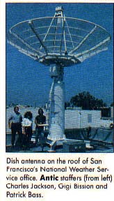
Dish antenna on the roof of San Francisco's National Weather Service office. Antic staffers (from left) Charles Jacksan, Gigi Bission and Patrick Bass.
NAM Schedule
Frequency (mHz.)        Time (GMT)
   3.357                2000-1400
   4.975                 24 hrs.
   8.080                 24 hrs.
   10.865                24 hrs.
   16.410               1400-2000
   20.015               1200-2400
You can also use Antic's WEFAX Decoder program to receive "wire-photos" from news agencies such as the Associated Press. Press photos can be found on many shortwave frequencies. These photos are transmitted at 60 lines per minute. We should point out that if you receive a "non-broadcast-class" signal (such as private communications), the Federal Communications Act states that you may not "divulge to any other party that such a transmission exists, or the content of the transmission 'intercepted'." This rule does not apply to the WEFAX signals described in the article, but it does cover other satellite transmissions you might receive with the our WEFAX Decoder program. These protected transmissions include (but are not limited to) all communications in the 3.7--4.2 gHz. band.
For a complete listing of WEFAX and news photo stations, refer to the Shortwave Facsimile Frequency Guide, by Joop Balneger and Michiel Schaay. It is available for $14.95 from Universal Electronics, Inc., 4555 Groves Road, Suite 13, Columbus, OH 43232. (6l4) 886-4605.
NAFAX
If you don't own a shortwave radio, it's possible (but not inexpensive) to receive WEFAX transmissions over the telephone. The National Facsimile Circuit (NAFAX) lets you tie into the National Weather Service (NWS) circuit, which broadcasts WEFAX satellite photos and weather maps 24 hours a day at 120 lines per minute.
Access to the NWS circuit is free, but you have to pay AT&T Longlines for the "Receive-Only Extension" of the NAFAX circuit. (You'll also need a FAX permit from the NWS.) The installation fee for a NAFAX extension is approximately $222. Monthly rates begin at $36.80. For more information, contact AT&T at (800) 222-0400, ext. 3557.
FACSIMILE
Facsimile machines were developed to transmit documents and black-and-white photographs over radio and telephone lines. The satellite weather maps you see on TY are transmitted this way, as are the "wirephotos" you see in newspapers and magazines.
Facsimile technology is a product of the 1930s. The earliest facsimile machines were hand-cranked and used spinning metal drums and brass gears. Later models featured electric motors.
Although most modern weather satellite stations use high resolution digital laser facsimile computers to produce their maps and photos, mechanical facsimile recorders are still the machines of choice among WEFAX enthusiasts. Mechanical facsimile machines are relatively inexpensive (starting at under $100) and can easily exchange pictures with state-of-the-art computerized facsimile machines.
Although these two types of machines are separated by more than 50 years of technical advances, the principles behind them are the same. In fact, most WEFAX programs for microcomputers, such as the programs in this issue, are modeled after mechanical facsimile equipment.
The heart of a mechanical facsimile transmitter is a rapidly spinning drum. The photo to be sent is wrapped around this drum, much like a label is wrapped around a coffee can. A standard drum measures 152 mm in diameter (about 6 inches) and is at least 660 mm long (about 26 inches).
The drum normally spins at 120 RPM, although speeds of 60 and 180 RPM are also used. Since one revolution is equal to one scan line, drum speeds are usually reported as lines per minute (LPM). As the drum spins, a small arm creeps alongside it, moving about one inch with every 96 revolutions. The arm carries a small light and a photocell. The photocell scans each line of the image, one dot at a time, and generates a small electric current for each dot. The current is proportional to the darkness of the dot. The transmitter broadcasts this varying current as a varying tone.
Darker dots produce lower-pitched tones, while lighter-colored dots yield higher-pitched tones. If we played a musical scale into our WEFAX machine, for example, we'd see a gray scale ranging from black to white. The scale would have to be played very quickly, though. A drum speed of 120 LPM means that WEFAX images are being transmitted at two lines per second. A facsimile receiver running at the same speed can intercept these signals and reverse the process to generate a copy of the image.
In practice, WEFAX tones range from 1500 Hz. (black dots) to 2300 Hz. (white dots). WEFAX images also contain a short "dead sector" which corresponds to the left and right margins of the image. This is where the photo is attached to the spinning drum. Since WEFAX transmissions have no timing signals (such as the horizontal sync signals used in TV broadcasts), the dead sector is commonly used to align an incoming picture.
Generally, a WEFAX signal sounds very much like cricket chirping at two chirps per second. Each "chirp" corresponds to a single horizontal scan line of the image.
A standard WEFAX image is composed of 800 of these lines, stacked one on top of the other. Since each scan line is transmitted as a half-second analog signal (at 120 LPM), it can be divided into as many pixels as you please. Of course, a scan line divided into 800 individual pixels will have a much finer resolution than one which is divided into eight.
GOES SATELLITES
British writer and scientist Arthur C. Clarke first proposed the concept of geosynchronous satellites in a 1945 edition of "Wireless World." Such satellites, he speculated, could he used to relay messages from one side of the globe to the other. Since that time, the ring in which geosynchronous satellites must be placed has been named the Clarke Zone. To date, more than 150 geosynchronous satellites have been placed in this zone.
WEFAX pictures come from the polar orbiting NOAA satellites or from a Geostationary Operational Environmental Satellite (GOES). GOES satellites, positioned over the earth's equator at an altitude of approximately 22,300 miles, orbit the earth once every 24 hours.
GOES satellites remain in synchronous orbits around the earth. In other words, geosynchronous satellites don't rise or set. Day and night, they remain in the same position, relative to the earth. Thus, ground stations only have to aim their antennas once.
Left to their own devices, GOES satellites will stay frozen in their assigned positions in the sky, apparently: "hovering" over whatever line of longitude they were assigned. These satellites may be easily moved, however, to suit the needs of scientists and meteorologists. A ground station may move a GOES satellite by temporatily altering its altitude; a GOES satellite brought closer to the earth will appear to drift east, while one moved away from the earth will drift west. Once repositioned, the ground station returns the satellite to its original altitude.
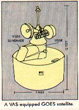
The newer GOES satellites are shaped Like large cylinders. Built by the Hughes Aircraft Company, each measures 7 feet in diameter, nearly 12 feet in length, weighs 1,382 pounds and costs more than $57.5 million. They are powered by external solar cells which provide up to 320 watts of electric power.
Although six GOES satellites were launched, only one remains operational. Previously, the United States was monitored by two GOES satellites. GOES-5, launched in May 1981, monitored the eastern half of the country. GOES-6, launched in April, 1983, observed the western half.
GOES-5 failed in July, 1984. Since that time, NOAA has moved GOES-6 to 108 degrees W. longitude to monitor the entire country. During hurricane seasons, however, GOES-6 is moved to 98 degrees W. longitude to provide increased coverage of the Caribbean regions.
GOES-7, which would have replaced GOES-5, was launched from Cape Canaveral on May 3, 1986. Moments after launching, though, the Delta booster rocket failed, and the spacecraft had to be destroyed. Spokesmen for the Kennedy Space Center said that no further GOES launches are presently scheduled.
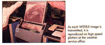
As each WEFAX image is transmitted, it is reproduced on high speed plotters at the weather service office.
GOES INSTRUMENTATION
The primary instrument aboard the early GOES satellites was a Visible and Infrared Spin-Scan Radiometer (VISSR), which is akin to a facsimile machine's spinning drum and photocell.
VISSR can transmit either visible or infrared images of the earth. With this technology GOES satellites could supply weather photos both in daylight and at night, 24 hours a day, at a rate of one picture every 30 minutes.
Between 1980 and 1983, a more advanced series of GOES satellites was launched. GOES-4 through GOES-6 were each equipped with a 16-inch (40-cm) telescope capable of optical and infrared viewing, as well as a VISSR-based Atmospheric Sounder (VAS). Atmospheric sounders were first used on the Nimbus weather Satellites to measure the air's temperature and moisture content at various altitudes.
Satellites with VAS can transmit an interlaced signal which contains both visible and infrared images of the earth. Even-numbered "chirps," for example, contain the optical image, while odd-numbered "chirps" carry the infrared image. This is called "simultaneous imaging." In other words, a VAS aimed at one section of the earth will simultaneously create two different types of pictures (infrared and optical) at the same time (See Figures 1 and 2).
VAS operates 24 hours a day, observing clouds, cloud heights, vertical temperature distributions and wind patterns. As infrared and optical images highlight different aspects of the earth, meteorologists armed with both types of images have nearly twice as much information with which to make a forecast.
SIGNAL RELAYS
Although it's possible to receive images directly from the satellite, the process is often too costly and too inconvenient for most WEFAX users.
Weather satellites usually transmit images on S-band microwave frequencies (about 1691 mHz.). Although such frequencies experience little interference and are excellent for satellite-to-ground communications, they are not very practical either for earth stations to use when broadcasting to ships, or for other WEFAX users. For one thing, at the time most of today's ships were built, the necessary microwave receivers were too large, too expensive and too difficult to maintain. But this situation is being reversed with the advent of satellite TV.
However signals transmitted over VHF and microwave frequencies may only travel as far as the eye can see. "Line-of-sight" transmission poses little problem to the satellite-based transmitter--its line-of-sight spans nearly half the globe. Earth-based stations, on the other hand, are not as fortunate. A ship would have to be in sight of a transmitter in order to receive a picture from it.
This is why the final WEFAX signal is broadcast in the shortwave bands. Shortwave frequencies, though slightly noisier, have a much greater range. Many shortwave radio enthusiasts commonly receive signals from the other side of the world.
Shortwave radios are also less expensive than their S-band counter-parts. Although S-band satellite receivers are quite expensive and usually require special parabolic dish antennas, shortwave receivers are relatively inexpensive. All you need is a shortwave receiver capable of receiving SSB (Single Sideband)--the kind most amateur radio operators use--and an appropriate interface to decode the WEFAX signals. A suitable second-hand receiver can be purchased for as little as $75-$100.
FIRST-HAND SIGNALS
Although shortwave WEFAX stations use many formats, protocols and frequencies to relay WEFAX pictures, geostationary satellites adhere to a single format. All geostation;iry meteorological satellites use a common downlink frequency of IG91.0 mHz. The format of WEFAX data is identical for all satellites. Many WEFAX enthusiasts take advantage of this standard to receive images first hand.
Ambitious readers handy with a soldering iron may want to try receiving pictures directly from space! S-Band Receiving System for Weath Satellites" (~ST MaRazine, August' 1()80, pp.28-33), gives instructions for downconverting the 1691.0 mHz. downlink signal to a 20.6 mHz. signal, which can be received by standard shortwave radios.
You could also try receiving WEFAX from some of the polar orbiting satellites. These satellites are in sun-synchronous orbits at altitudes ranging from 435 to 1055 miles above the~ earth and have orbital periods between 98 and 120 minutes. A "sun-synchronclus" orbit refers to the circle traced by the orbiting satellite. To an observer standing on the sun, this, circle would look like a stationary ring around the earth. To an observer on the earth, a sun-synchronous satellite wauld pass overhead at about the same times every day.
The NOAA polar orbiters transmit satellite pictures on 137,5 and 137.62 mHz. The Soviet METEOR satellites transmit pictures on 137.3 and 137.15 mHz.
Antic would be eager to hear from readers having success with such projects.
Listing1:WEFAX.1 Download
Listing2:WESIM.BAS Download